 eAtlas Data Catalogue
TropWATER, James Cook University (TropWATER/JCU)
Type of resources
Topics
Keywords
Contact for the resource
Provided by
Years
Formats
status
-
This project will examine the status, diversity and condition of mangroves and freshwater habitats in the Torres Strait. This will provide a baseline against which future changes can be assessed and will also enable planning for adaptation to potential sea level rise/increased storm surge. The project builds on Torres Strait Islanders’ knowledge and understanding of mangrove habitats, with scientists working in partnership with Traditional Owners. This project will: 1. Undertake a baseline survey of the status and condition of mangroves and freshwater wetland habitats in Torres Strait based on a combination of aerial imagery and on-ground surveys, including documenting species present and identifying the presence of exotic species. 2. Where feasible, document knowledge of selected communities about their uses of mangrove and freshwater habitats and provide management advice for these habitats, where required. 3. Assess mitigation options for mangroves, protection/management/rehabilitation needs, and climate change-related adaptive strategies.
-
The Reef Rescue Marine Monitoring Program (RRMMP) has identified that seagrass meadows along the Great Barrier Reef are in a state of decline. This project will undertake desktop analyses to quantify the exposure of seagrass meadows to flood plumes. Aquaria experiments will measure responses of seagrass to variation in light, nutrients and salinity. This project will also use use True Colour Remote sensing images, to derive flood plume exposure and relate to changes in seagrass abundance and composition. The results will be synthesised to define thresholds of concern of water quality impacts, with a particular focus on flood plumes, and input into the development of guidelines for the protection of seagrass meadows. Tasks include: 1. Quantifying the level of exposure of seagrass meadows to changes in water quality associated with flood plumes (using True Colour Remote sensing) in coastal regions of the GBR. 2. Measurement of changes in biological traits (e.g. growth, biomass) of seagrass in relation to water quality (Light, nutrients, salinity) determined by experimental studies. 3. Experimental testing of indicators of seagrass status adopted in the Great Barrier Reef Marine Monitoring Program (MMP) (e.g. nutrient ratios) in response to changes in water quality. 4. Experimental verification of water quality response models and thresholds, in particular in relation to the MMP.
-
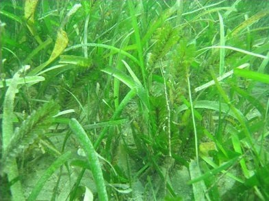
The aims of this work (MTSRF Project 1.1.3b) were to identify the role of light and water temperature as drivers of change in seagrass meadows of the northern Great Barrier Reef. Experimental approaches as well as field investigations were undertaken. Field studies occurred at four locations (Magnetic Island, Dunk Island, Green Island, Low Isles). There was continuous monitoring of light and temperature at seagrass canopy height in both intertidal (above lowest astronomical tide, LAT) and near-by subtidal meadows (1-3m below LAT) at each of the four locations. Approximately every 3 months, seagrass response variables were also measured, including, percent cover, growth, seagrass morphology and physiology. There were three experiments testing the effects of temperature and/or light on tropical seagrasses. 1. A shading experiment where seagrass response variables were measured for 102 days at four light levels: high light (66% surface light), moderate (31%), low (14%) and very low light (1%). 2. A pulsed temperature experiment where short-term spikes of water temperature to 35, 40 and 43°C, which mimic current temperature ranges during low tide in the GBR, were applied for 6 days followed by one day of recovery. 3. A temperature and light interaction experiment at 27, 30 and 33°C, which spans current and future predicted summer water temperature, at saturating (400 µmol photons m-² s-¹) and limiting light levels (40 µmol photons m-² s-¹). Results indicated that low light levels had a significant impact at field study sites during the monitoring period with subtidal meadows often pushed below minimum light requirements during the monsoon season. This combined with ongoing low light events throughout the year (probably due to re-suspension of sediments by tides and wind) was associated with substantial loss of seagrass at Magnetic Island (from 45% cover to 1% cover from January 2008 to April 2010) and loss also occurred at Dunk Island and Low Isles. The light levels and duration of impact are similar to those resulting in shoot loss during experiments. There was little indication of temperature related stress during the field studies up to April 2010; however, the temperature experiments, in conjunction with future predictions of water temperature, indicate that water temperature will become a significant driver in GBR seagrass meadows. Data Units: Field: * Light (recorded every 30mins), available as µmol photons m-² d-¹ * Temperature (°C recorded every 1.5hrs) * Subtidal/intertidal habitat * Seagrass species: Cymodocea serrulata, Cymodocea rotundata, Halodule uninervis, Thaalssia hemprichii and Zostera muelleri. * Seagrass response variables: percent cover, biomass, morphology (leaf dimensions, leaves per shoot, rhizome internode length and branching distance), leaf growth rates, carbohydrate storage reserves and photosynthetic pigments (Chlorophyll a+b). Experiments: * Light: Shading experiment - high (66% surface light), moderate (31%), low (14%) and very low light (1%) and temperature x light experiment - high light (400 µmol photons m-² s-¹) and low light (40 µmol photons m-² s-¹) * Temperature: Pulse experiment - ambient to 35, 40 and 43°C; and temperature x light experiment - 27°C, 30°C, 33°C * Seagrass response variables: shoot density, biomass, leaf growth rates, morphology (leaf dimensions, leaves per shoot), carbohydrate storage reserves, photosynthetic pigments (Chlorophyll a+b), photosynthetic efficiency (PSII (effective PSII quantum efficiency) & Fv/Fm (maximal photochemical efficiency)) and rapid light curves. Publications: - Collier CJ, Uthicke S, Waycott M (2011) Thermal tolerance of two seagrass species at contrasting light levels: implications for future distribution in the Great Barrier Reef. Limnol Oceanogr. 56 2200-2210, DOI: 10.4319/lo.2011.56.6.2200 - Collier CJ, Waycott M, Giraldo-Ospina A (In Press) Responses of four Indo-West Pacific seagrass species to shading. Marine Pollution Bulletin, DOI: 10.1016/j.marpolbul.2011.06.017 References: - Collier C and Waycott M. (2009) Drivers of change to seagrass distributions and communities on the Great Barrier Reef: Literature Review and Gaps Analysis. Report to the Marine and Tropical Sciences Research Facility. Reef and Rainforest Research Centre Limited, Cairns (55pp.). - Waycott M and McKenzie L. (2008) December 2008 Milestone Report. Report to the Marine and Tropical Sciences Research Facility. Reef and Rainforest Research Centre Limited, Cairns (9pp.).
-
This project involved an assessment of all existing and potential sources of pollution to the Torres Strait marine environment. This was combined with information on water movement patterns to assess the hazard (and to some degree risk) of these pollutant sources to marine ecosystems and public health. This project was predominantly a desktop study with some field work to sewage treatment plants, and other point sources of potential pollutants. This project: 1. Collated information regarding Torres Strait water quality pollutant sources at a range of scales (regional to local). 2. Developed a better knowledge of water circulation patterns in the Torres Strait region through the development of a fine-scale model based on the Slim model. 3. Developed a hazard assessment of the sources of pollutants that affect marine ecosystems and public health in the Torres Strait region. This will form the basis of recommendations to management authorities to prioritise investment and political action to minimise pollution and public health/marine ecosystem damage. 4. Established recommendations for a water quality monitoring program for the Torres Strait region, designed to assess the status of water quality and measure the effectiveness of pollution management actions.
-
This project undertook a scoping study to develop a robust approach that will allow us in Phase 2 to carry out an ecological risk assessment (ERA) of nutrients, fine suspended sediments, and pesticides used in agriculture in the GBR region including ranking the relative risk of individual contaminants originating from priority catchments to the GBR ecosystems using a systematic, objective and transparent approach. The researchers will specifically look at a method able to evaluate relative risk to different ecosystems and their keynote species from the different contaminants, e.g. suspended sediments versus nitrogen (and different forms of nitrogen) versus phosphorus (different forms) versus pesticides (different types). The results of the Phase 1 study were used to secure support to carry out a full risk assessment.